Autonomous Drones
All There’s to Know About Autonomous Drones
Drones these days get a bad rep. Guess that’s hardly a surprise when every headline is about another drone swarm taking an additional batch of human lives.
That’s not to say the disproportionate attention to the military use of drones is entirely fair. Because, within industrial settings, drones have propelled operational efficiency to a level none of us thought possible while sparing countless lives in the process.
On behalf of like-minded service providers who revel in the potential of drones to serve as an agent of the greater good, we hereby chart out all there’s to know about autonomous drones and how they’ve transformed our lives for the better.
What Makes a Drone Autonomous?

A drone is an umbrella term for any aircraft that can fly without a human pilot onboard. Hence the reason why a drone is often referred to as an unmanned aerial vehicle (UAV).
Now, there are two ways to go about flying an aircraft without giving direct commands. It can be controlled remotely or equipped with intelligent drone systems that allow the drone to self-pilot a premeditated flight path. The latter needs to be the case for a drone to be considered autonomous.
Are All Autonomous Drones Created Equal?
Here’s a million-dollar question. You see a drone zip through an obstacle course all by itself. Would that make the drone autonomous?
Well, not quite.
A considerable degree of autonomy is required to navigate a cluttered environment. Robust self-flying capacity, however, doesn’t make up for the whole story. For a flight to be truly autonomous, a drone must figure out when and where to fly, not just how.
Unfortunately, the level of technological maturity isn’t quite there yet. Whether it’s planning, dispatch, operational control, or postflight data analysis, a certain degree of human input is necessary to ensure the entire process remains airtight.
Levels of Autonomy

The chart above outlines different levels of drone autonomy. Let’s break it down a little more.
- Level 0. The pilot remains in full control throughout from takeoff to landing. Doomed to crash otherwise.
- Level 1. A specific function of the flight – generally position sensing or obstacle detection – is automated. Drones to remain in the pilot’s visual line of sight (VLOS).
- Level 2. Drones send out warning signs when an object moves in too close. The pilot is in charge of safe operation and keeping drones within VLOS.
- Level 3. The pilot is present purely as a backup. Payload comprised of devices and sensors allows drones to fly a pre-programmed path without running into obstacles.
- Level 4. On-site presence is no longer necessary. With clearance, operations can take place beyond visual line of sight (BLVOS) as drones are capable of flying through harsh conditions and have a failsafe to fall back on in cases of breakdown.
- Level 5. Drones handle all the legwork that goes into a flight. The technology and legal framework to accommodate full autonomy are still in the test phase.
Why Does Drone Autonomy Matter?
The degree of drone autonomy can make or break operational success.
Think about it. The whole point of using drones is to have them plow through and capture high-quality data from areas and assets that are either undesirable or unfit to be surveyed manually. With level 2 UAVs and below, the skill level of the operator will come to dictate how useful the collected data turns out to be.
Of course, this wouldn’t have been much of an issue had the talent pool of skilled pilots been deep. But tracking down an experienced and qualified operator who understands the structural complexity of the asset is like finding a needle in a haystack. And even when the right talent turns up, their services tend to cost all four limbs.
UAV Remote Sensing Applications
If you can’t already tell, the industrial use of autonomous drones is incredibly diverse–asset inspection, environmental monitoring, precision agriculture, site surveillance, and so forth so on.
One thing to note is that all these tasks fall under the roof of remote sensing, which, in essence, refers to contactless data collection.
So, how do autonomous drones go about remote sensing to collect aerial data? Three different ways.
Photogrammetry
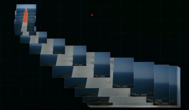
Perhaps the most well-established aerial surveying technique, photogrammetry captures hundreds and thousands of snapshots over a specific surface area before stitching them together into a three-dimensional (3D) rendering.
The value of resulting 3D models is proving to be immense. Particularly within the O&M industry that has long been putting up with inefficient and hazardous manual inspection processes, drone photogrammetry is turning out to be a game-changer.
If anything, a video is worth a million words. Check out the clip below to get a close-up look into how drone photogrammetry takes place within the context of wind turbine inspections.
Light Detection and Ranging (LiDAR)
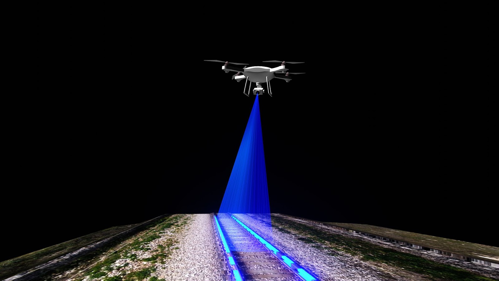
LiDAR won’t come to you as a brand-new concept should you be at all familiar with the workings of a radar.
As radar does with radio waves, LiDAR emits high-powered lasers at a target to measure the angle, intensity, and timing of the reflected pulses. The collected data points then go through mapping software to recreate a three-dimensional model, which helps site managers detect irregularities across a set area and gauge optimal uses of the land.
Keep in mind that the ability of LiDAR to provide a bird’s eye view of a mapped area doesn’t make up for the lack of photographic depth. To get the look and feel of a particular terrain supported by color and texture, you’ll need to opt for photogrammetry.
Thermal
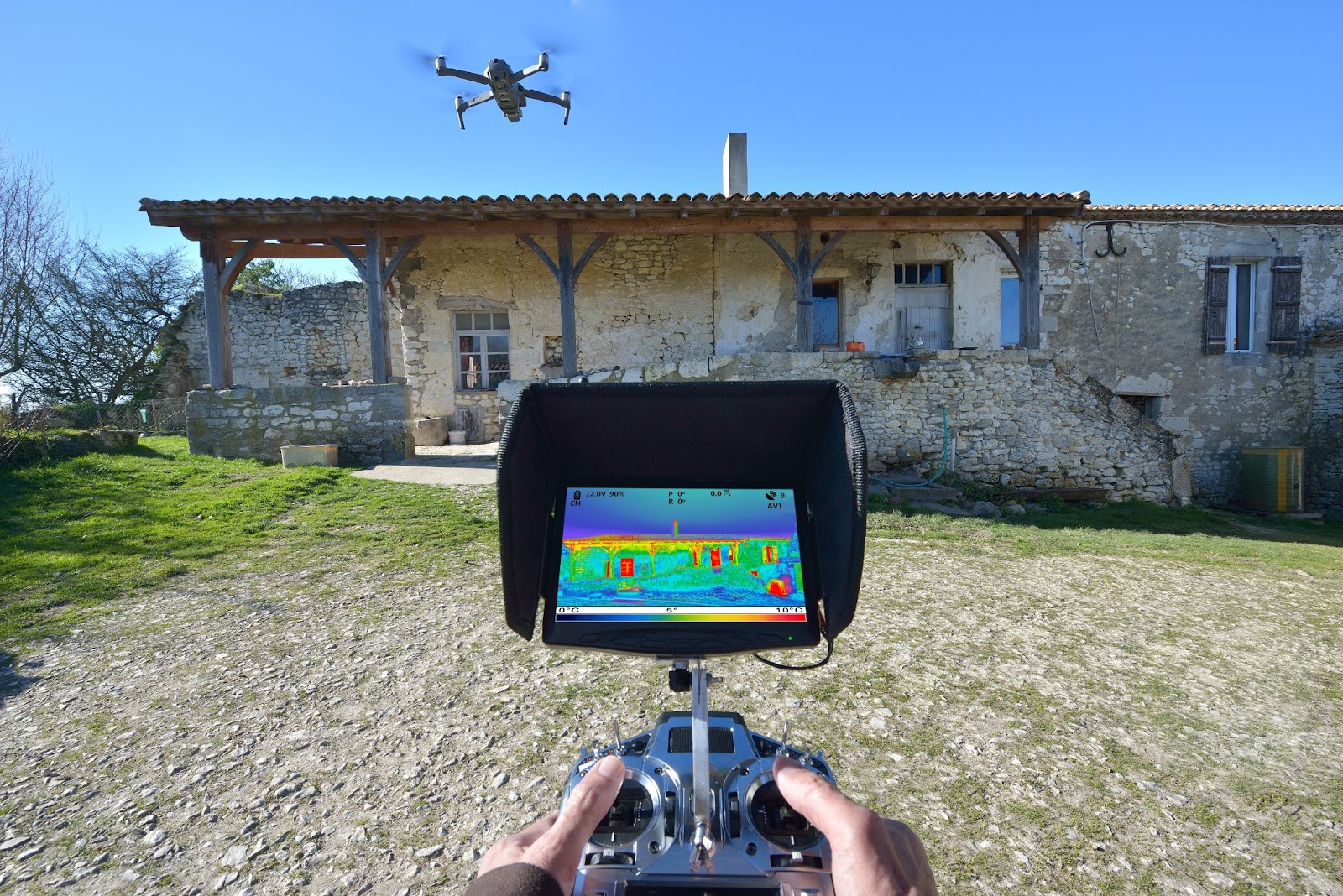
Not all defects are there for the naked eye to catch. Sometimes, the only way to make sure the assets are being maintained properly is to look past visual cues. An indicator that industries can resort to in those instances is heat.
Take a look at the transmission sector to see what thermal drones have to offer. Insulation is of paramount importance to transport materials from A to B. Cross-referencing heat levels across the pipeline brings out internal freezes and leaks into the open.
Thermal sensors, however, are uber-sensitive to weather conditions. To avoid the heatmap from coming out as a blur, the drones mustn’t be flown in windy or humid climates nor go past 8.95 miles per hour.
What Are Autonomous Drones Used For?
UAV-based remote sensing techniques have opened up new avenues of growth across industries.
Here’s how.
Agriculture
There’s more to agribusiness than meets the eye. Planting and watering crops don’t cut it.
Quality production depends on how well the crops can be preserved from constantly shifting environmental factors. To do so, farmers must keep close tabs on soil health, irrigation conditions, heat levels, and more.
Running a comprehensive farmland analysis meant tapping into aerial mapping services led by full-fledged aircraft. Now, an autonomous drone can get the job done on a weekly or even daily basis at a fraction of the cost, which perhaps goes to show why the global market for agricultural drones has grown from $494 million to $6.28 billion over the past six years.
Construction
Site selection forms the building block of any successful construction project.
The good news is construction managers don’t need to start from scratch. They usually have access to relevant maps and studies from previous projects. The bad news is the shape of the terrains is subject to constant change due to hydraulic erosion and sedimentation, and the information in front of them might as well be obsolete.
Thanks to drones, old literature isn’t all there is for site managers to go off of. They can get their hands on the latest topographic profile of a given terrain through autonomous flight. The 3D rendering modeled after high-resolution images helps site managers to make out preconstruction challenges and volumetric measurements, letting them double down on their construction plans.
With more than half of the civil construction projects relying on UAVs to handle everyday needs, the worldwide market for construction drones, currently at around $5 billion, is slated to double in value over the next five years.
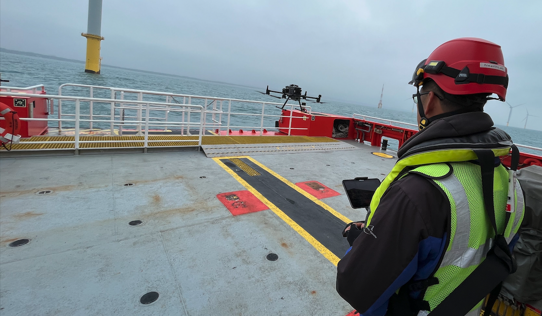
Infrastructure Inspection
Building assets from the ground up is one thing. Maintaining them is another.
More often than not, proper maintenance proves to be a tougher challenge than getting assets up and running. The reasons are twofold – 1) the pace of degradation tends to be faster as assets wear and tear with everyday use; 2) traditional means of inspections are ridden with costly, time-consuming, and potentially fatal manual processes.
Let’s take a closer look at how autonomous drones have changed the status quo under different industrial contexts.
Bridges
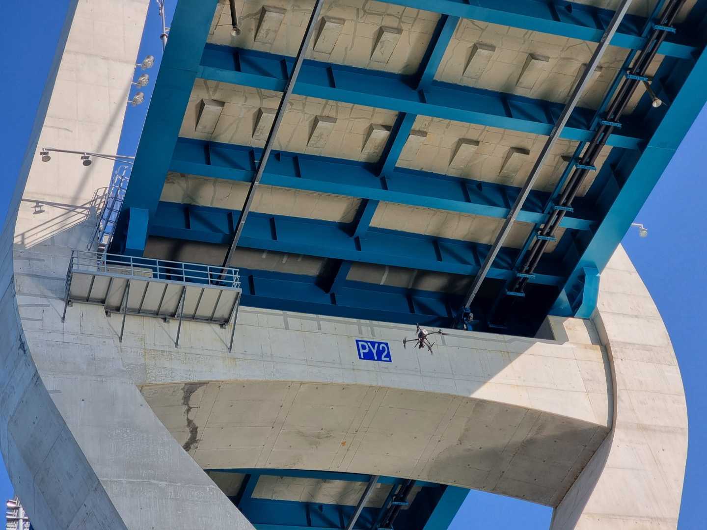
Do you remember all those times you had to take a roundabout route due to bridge-related lane closure? While certainly frustrating, now you can take comfort in that it isn’t your life hanging by a thread every passing second the bridge remains closed.
Before drones found their way into the scene, inspectors spent days rappelling across steel slopes looking for cracks and delamination. That’s to say inspections banked on the optical acuity of the technicians, which came at the risk of letting certain defects go unnoticed.
Letting drones do the work instead did wonders. It removed personnel from harm’s reach while giving way for artificial intelligence (AI) to catch the defects with pinpoint accuracy.
Mining
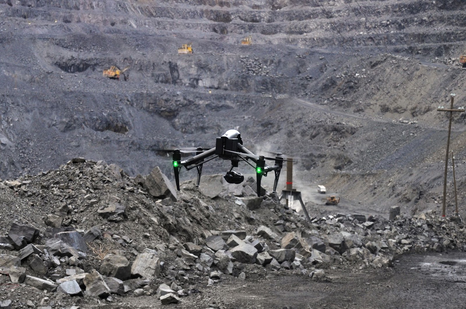
Mining is a precarious pursuit. Dubbed with the fact that the law mandates inspections to be done on a quarterly basis for underground sites, a mining company deals with a whole lot of responsibility to save their workers from getting exposed to toxic gases and hazardous wastes.
By virtue of autonomous drones, mining companies can now keep close tabs on coal, temperature, ore passes, and other areas of mining management without putting the well-being of employees at risk.
Utility Towers
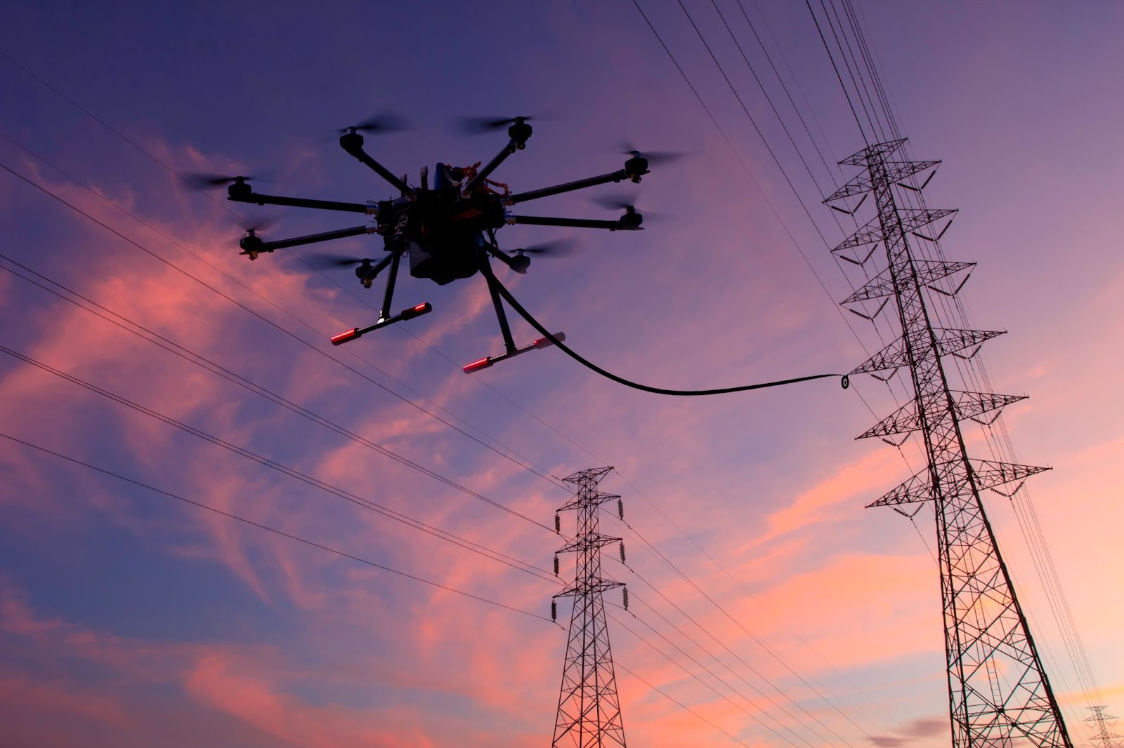
The tale of the tower inspections isn’t all that different from its bridge counterpart. Meaning it’s the sacrifices rope-access technicians have made behind the scenes that give us the privilege of being able to enjoy fast and stable network services around the world.
But now that carriers are calling for enhanced 4G and 5G capacity left and right, mustering up the manpower to accommodate the growing demand for bigger and better cell towers will be a Herculean challenge.
Well, if UAVs hadn’t been a thing, that is.
Equipping the drones with computer vision and cameras, inspections are done in a matter of hours without forcing anyone to crawl around the tower at a staggering height.
Wind Turbines
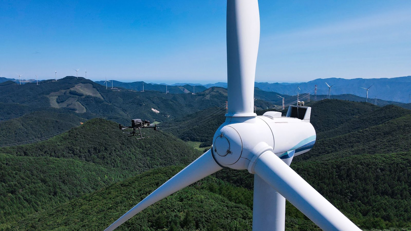
Now, you might have noticed a bit of a theme going around here – vastly cheaper, faster, and safer means of inspection. That’s the name of the game when it comes to the industrial applications of UAVs.
Wind energy is no exception. Drones have completely changed the way turbines are looked after.
Asides from giving turbines a rough scan with a binocular or camera from the ground, there were two ways to go about turbine inspections before drones were introduced. Either set up a scaffold around the turbine or bring in a technician for a rope access operation. As you can imagine, neither proved particularly productive nor reliable, with a typical turnaround time of no less than six hours.
Meanwhile, drones take more or less 15 minutes to survey a full-sized turbine. Research has shown that highly autonomous solutions such as NearthWIND Pro can lead to a 70 and 90 percent drop in inspection and downtime costs, respectively.
All this is to say that the efficacy of UAV technology is resounding through the corridors of industrial facilities, which is set to culminate in a $35 billion drone inspection market.
Public Safety
Put yourself in the shoes of a new police recruit dispatched to a crime scene.
All psyched up to make your first arrest, you hop in your cruiser and rev up the engine. As it turns out, the road has zero concern for your heroic pursuit, as illustrated by the traffic jam. Once you arrive at the reported site, it’s ten minutes too late, and you’re back to square one.
The point here is police work happens on the fly. But the mobility of most vehicles is compromised by a host of factors, including accidents, traffic jams, and road work.
Now, imagine there had been a drone tied to the top of your cruiser. Treating the patrol car as a base station, the drone is deployed to capture the crime scene as it unfolds and provide you with the much-needed situational awareness to chart out the next steps.
Make no mistake. The market for public safety drones is relatively nascent. It may be a while before we see drones take part in routine police work. For the time being, drones are used to put together 3D orthomosaic maps to help preplan emergencies and reconstruct accidents.
The Future of Autonomous Drone Solutions
The best part of it all is that there’s still much room for innovation when it comes to commercial drone use.
Namely, a world where self-reliant drones float through the sky is no longer science fiction. As we transition to that very future, companies that harness the power of autonomous drones will be able to get more done in less time, unlocking next-level productivity and growth.
Don’t know where to start? Find out how Nearthlab’s suite of autonomous drone solutions can help you gather and analyze aerial data in an efficient and seamless fashion. Unlock actionable insights that drive your business forward.